Soils
Soils provide the foundation of the region’s prosperity. Wimmera soils underpin the strong agricultural sector that contributes almost $800 million pa to local economies and significant contributions to Victoria and Australia’s export grain and dairy markets. Australia and Wimmera’s soils are some of the oldest in the world and are vulnerable to the loss of top soils due to wind and water erosion and compaction. There is significant variability in soil structure, texture, and composition in the Wimmera, even at the paddock scale. Wimmera CMA works closely with agricultural service providers to improve landholders’ knowledge, skills, attitude, and understanding of these precious resources to ensure that future generations and local economies can rely on agriculture.
The majority of soils are used to support a large agricultural industry as well as the biodiversity and vitality of native flora and fauna.
Sustainable management of soils is critical for maintaining Victoria and Australia’s economy and providing national food security.
Sustainable management of soils on private land also influences the health of other natural assets, such as native vegetation and waterways. By reducing the threat of soil to degradation, we improve soil fertility and protect other natural assets.
Wimmera Soils
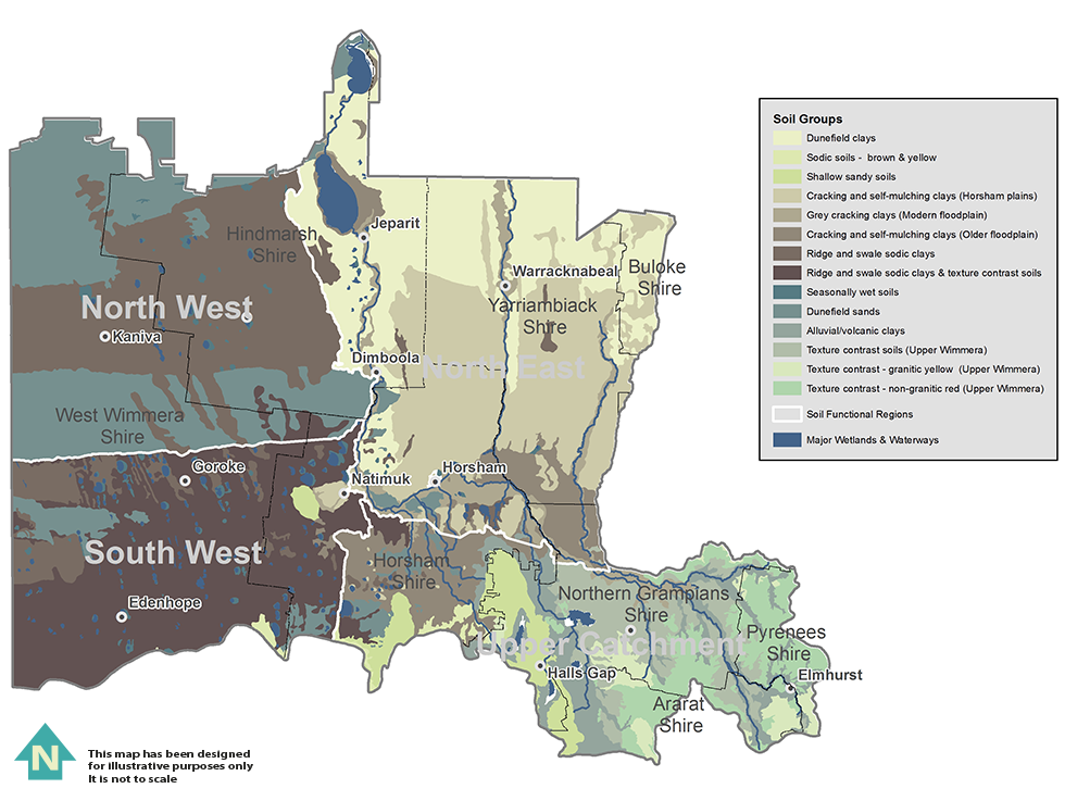
Wimmera soils are highly variable at both regional and local scales; with multiple soil types often present in a single paddock. Different soil types have different susceptibilities to degradation.

- Texture contrast soils of the Upper Catchment are naturally susceptible to water erosion
Texture contrast soils have characteristically light, sandy/loamy surface soils that overlay heavy clay subsoil. The heavy clay subsoil tends to be compacted with limited drainage capacity. Light topsoil that overlays the poorly drained subsurface clay is easily removed by water especially on steep landscapes where rainfall is high (greater than 500mm.) - Sandy soils of the Northern Plains are naturally susceptible to wind erosion
Light, sandy soils with low clay content that form in arid areas are easily moved by wind. In the Northern Plains light, sandy soils are characteristically eroded by wind and move as sand drifts or, if fine enough, dust clouds. - Acid soils are concentrated in the Upper Catchment
Acid soils, (with a pH of less than 7,) form when calcium, magnesium, potassium, and sodium ions are rapidly leached from the soil profile. They are therefore, generally restricted to higher rainfall areas (greater than 500mm). In the Upper Catchment, acidic topsoil is very common and is often associated with aluminium toxicities - Sodic subsoils are widespread throughout the Wimmera catchment
Sodic soils have high sodium content and, whilst widespread, are particularly characteristic of ridge and swale systems in the South-west Wimmera and Northern Plains. Dispersion of sodium in the subsoil can cause subsoil erosion, gully erosion, compaction, and water logging. - Soils throughout the Wimmera catchment are naturally saline
Salinity has accumulated in the landscape over the last few million years (primary salinity) and remobilised due to subsurface water flows. Primary salinity occurs in sedimentary basins, alluvial deposits, and sand dunes (South-west Wimmera and Northern Plains). Primary salinity is also associated with deeply weathered granites and fractured rocks from the higher relief areas of the Upper Catchment.
Degradation processes that naturally occur in the environment can be managed on private land through best land management practices. Many farmers acknowledge that adoption of best management practices will improve their soil health and have expressed keen interest in learning more about managing soil health.
Wimmera CMA undertakes planning and funds projects to help farmers manage threats to agricultural land, especially salinity, wind erosion, water erosion, and loss of organic matter and nutrients. The objective is to manage agricultural land within its capability and to maintain and enhance the region’s soils, while improving and sustaining the profitability of the agricultural sector.
Partnerships with service providers such as the Department of Environment and Primary Industries and farmer industry groups such as Perennial Pasture Systems (PPS) and Victorian No Till Farming Association are critical to achieving these outcomes.
The ways in which Wimmera CMA encourages practice change includes:
- managing the Catchment Tender Project which rewards landholders for planting trees to lower saline groundwater tables
- facilitating Farm Plan 21
- supporting Wimmera Landcare
- supporting and participating in knowledge sharing with interest and industry groups
- sharing knowledge through field days and events
- research and development activities.
Dryland salinity
Dryland Salinity is the process that degrades land due to an increase in soil salt concentration. Being in excess of normal soil salt concentrations makes it harder for plants to take water from the soil and eventually they die from dehydration, leaving patches of soil with no ground cover.
Dryland salinity is caused by rising water tables.
Some ways this can occur:
- Clearing deep-rooted perennial native vegetation and replacing it with shallow rooted annual plants. The shallow roots are no longer able to utilise the excess runoff, and it now seeps past the roots zone to enter the groundwater system
- Excessive groundwater recharge; this could come from increased rainfall or floods
- Natural groundwater discharge; due to the relatively flat landscape, the water table does not need to rise far to reach the vegetation or discharge on the surface.
Putting perennial plants back in to the agricultural landscape is one way to limit dryland salinity.
Dryland salinity appears to have stabilised across the catchment. However, heavy rainfall and flooding, recharging of groundwater systems may lead to expanded areas affected by salt in the near future.
Even though the problems of dryland salinity appear to have stabilised for the moment, Wimmera CMA continue to monitor a number of bores to track any changes in groundwater levels over time.


